You can own the best rods on the planet. You can have a tackle box worth more than your boat payment. But if you park on the wrong spot, none of it matters.
Spot selection is where tournaments are won and lost. It is the single decision that determines whether you spend six hours getting bit or six hours staring at a dead graph. And here is the part most articles get wrong: the "right spot" is not a single thing. It is the intersection of structure, cover, water temperature, dissolved oxygen, forage location, wind, current, seasonal phase, and time of day. Each of those is one variable in a larger equation. The question is never "where should I fish?" in isolation. The question is: how much weight does each variable carry today, on this lake, at this water temperature, in this wind?
That is the Variable Equation approach to spot selection. Let me walk you through how I break it down.
Structure vs. Cover: Get the Definitions Right
Before we go any further, let me clear up the most commonly confused terms in bass fishing. Structure and cover are not the same thing, and confusing them will cost you fish.
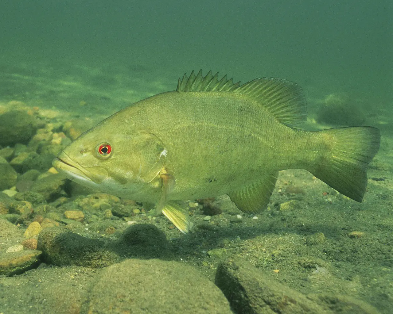
Structure is the shape of the bottom itself. It is the permanent contour of the lake floor: points, humps, ledges, drop-offs, creek channels, roadbeds, saddles, and flats. Structure does not move. You can find it on a contour map before you ever launch the boat. Think of structure as the highway system bass use to move between deep and shallow water.
Cover is the stuff sitting on or near that structure: rocks, stumps, fallen trees, docks, brush piles, and vegetation. Cover is what bass hide behind to ambush prey or avoid predators. Cover can change over time (trees fall, vegetation grows and dies), but it is always secondary to the structure it sits on.
Here is the key insight: cover on structure is where you find bass consistently. A random stump on a flat might hold a fish. That same stump sitting on a point that drops from 6 to 20 feet will hold fish all year long. The structure funnels bass movement; the cover gives them a reason to stop.
When I am pre-fishing a tournament lake, I start with structure every time. I pull up the contour map and identify the depth changes first. Then I look for cover positioned on those depth changes. That combination narrows the water faster than anything else.
The Big Three: Temperature, Oxygen, and Depth
If structure is the highway, then temperature and dissolved oxygen are the lane markers that tell bass which part of the highway they can actually use. These three variables work together to set the depth range where bass will hold on any given day.
Water Temperature Sets the Neighborhood
Bass are cold-blooded. Their metabolism, activity level, and location all follow water temperature. But the optimal range varies by species, and getting the numbers wrong means fishing the wrong depth zone.
Largemouth bass prefer water in the 82-84 F range (final thermal preferendum of 28-29 C), with growth optimized between 79 and 84 F (Diaz et al. 2007, Aquaculture Research; Coutant 1975). Florida-strain largemouth push even warmer — their critical thermal maximum runs 2-3 F higher than northern-strain fish (Fields et al. 1987, Trans. Am. Fish. Soc.), and laboratory preference trials confirm Florida-strain bass select temperatures 1-2 F above their northern counterparts (Koppelman, Whitt & Philipp 1988, Trans. Am. Fish. Soc.). If your lake has Florida genetics (common across the southern tier), those fish will hold slightly deeper in summer and tolerate shallower water longer in spring than a pure northern population.
Smallmouth run cooler, with a preferred range of 68-82 F and peak growth near 79 F (Horning & Pearson 1973, J. Fish. Res. Board Can.; Jenkins & Burkhead 1993). Smallmouth stress does not set in until water exceeds 86 F — well above the old conventional wisdom of 80 F — with positive growth documented up to 84 F (Horning & Pearson 1973). First-year smallmouth survival is tightly coupled to growing-season temperatures; stochastic modeling shows that a cold first summer can collapse year-class strength entirely (Shuter et al. 1980, Trans. Am. Fish. Soc.).
Spotted bass consistently select the warmest temperatures among all three black bass species in laboratory preference experiments (Cherry, Dickson & Cairns 1975, J. Fish. Res. Board Can.), though their observed summer habitat temperature of approximately 75 F (Coutant 1975) reflects field conditions where additional variables like dissolved oxygen and forage constrain depth selection. That thermal hierarchy — spotted (warmest-tolerant), then largemouth, then smallmouth (coolest) — matters when you are choosing depth on a multi-species fishery.
In practical terms: bass position themselves at the depth where the water temperature falls within their preferred range. In spring, that means shallow (spawning begins at 59-68 F for largemouth per Heidinger 1976 and Stuber et al. 1982, and 59-65 F for smallmouth per Turner & MacCrimmon 1970 — with smallmouth running about 3-5 F cooler than largemouth according to Graham & Orth 1986, Trans. Am. Fish. Soc.). Spotted bass spawn across a similar 59-68 F window (Churchill & Bettoli 2015, AFS Symposium 82; Vogele 1975, USFWS Technical Paper 84). In summer, it means deeper structure where temperatures stay below the stress threshold. In winter, they seek the most thermally stable water available, which is usually the deepest accessible structure.
Dissolved Oxygen Sets the Ceiling
Temperature tells you where bass want to be. Dissolved oxygen tells you where they can be. This is the variable that most anglers overlook entirely, and it explains why a "perfect-looking" spot on the graph produces nothing.
The peer-reviewed thresholds break down like this:
- Below 2.0 mg/L: Largemouth bass actively avoid this water. Telemetry studies show behavioral changes (yawning, vertical movement) at this concentration (Hasler et al. 2009, Physiological and Biochemical Zoology). The USFWS Habitat Suitability Index rates water below 2.0 mg/L at only 0.1 out of 1.0 (Stuber, Gebhart & Maughan 1982). One detail worth knowing: larger bass avoid hypoxia sooner than smaller fish (Burleson, Wilhelm & Smatresk 2001, Journal of Fish Biology). That means the big ones leave a depleting zone first — if you are only catching shorts in an area, oxygen may be marginal and the quality fish have already moved.
- 2.0 to 3.0 mg/L: Bass can survive here temporarily but foraging efficiency drops dramatically. Prey consumption and handling efficiency both decrease significantly at 3.0 mg/L compared to saturated conditions (French et al. 2018, Ecology of Freshwater Fish).
- 3.0 to 5.0 mg/L: Marginal habitat. Bass may hold here but are stressed and less likely to feed aggressively. The USFWS HSI model rates this range at 0.4 out of 1.0.
- Above 5.0 mg/L: Optimal. Healthy habitat that supports active feeding. HSI rating above 0.8 (Stuber et al. 1982).
What does this mean on the water? It means every spot you choose has a DO-driven depth ceiling. Below that ceiling, the fish are not there — period. And that ceiling changes with season, wind, water clarity, and the thermocline.
The Thermocline: Summer's Hard Boundary
In summer, lakes stratify into three thermal layers. The warm upper layer (epilimnion) sits on top. The cold bottom layer (hypolimnion) sits below. Between them is the thermocline — a narrow band where temperature drops rapidly with depth.
Here is why the thermocline matters for spot selection: below the thermocline, dissolved oxygen depletes as summer progresses. Organic matter decays, bacteria consume oxygen, and nothing replenishes it because the thermal layers prevent mixing. Eventually the hypolimnion becomes a dead zone. Bass will not hold below the thermocline in a stratified lake because the oxygen is not there to support them.
The depth of the thermocline varies by lake. In stained or dingy water, it may sit at only 6 to 8 feet. In clear water, it can push down to 25 or 30 feet. Water clarity is the primary driver, followed by lake surface area. When you find the thermocline on your graph (look for the band where arches and bait disappear below), you have found the maximum effective depth for your spot selection. Everything below it is dead water.
This is why "deep structure" does not always mean "better." A 35-foot hump in a lake where the thermocline sits at 18 feet is worthless in July. But a 15-foot hump in that same lake could be loaded, because it sits in the oxygenated zone with temperature in the bass's preferred range.
Reading Contour Lines: Finding Structure Before You Launch
One of the fastest ways to eliminate unproductive water is to study a contour map before you ever turn the key. Contour lines represent changes in depth, and the spacing between those lines tells you the shape of the bottom.
Close together: Steep drop-off or bluff. Bass use these as vertical migration routes and ambush walls.
Far apart: Gradual flat or shelf. These are staging areas, especially in spring when bass move shallow to spawn.
Lines forming a V or U pointing toward deep water: A point extending from shore. Points are among the most consistent bass-holding structures in any lake because they serve as highways between deep and shallow water.
Concentric circles: A hump or underwater island. If it tops out in the right depth range (above the thermocline, in the temperature sweet spot), these can hold fish year-round.
Lines paralleling a channel: A creek or river channel. The channel edge (where the flat meets the drop) is prime real estate for bass positioning.
Maps with 5-foot contour intervals give the clearest picture for bass fishing. Look for irregularities — a slight bend in a channel edge, a small secondary point on a larger point, a hump adjacent to a channel swing. Bass concentrate on these subtle features because they provide the intersection of depth change and feeding opportunity.
Key Structure Types and How Bass Use Them
Points
A point is a piece of land or bottom that extends outward from shore or from a larger structure into deeper water. Points are the most versatile structure in bass fishing because they serve as transition zones between shallow feeding areas and deep resting areas.
Bass use points differently by season. In spring, they stage on the deeper end of points before moving shallow to spawn. In summer, they position on the deeper edges where the point meets the thermocline zone. In fall, they use points as ambush stations as baitfish migrate into creek arms. In winter, they drop to the deepest end of the point or adjacent channel.
The key to fishing a point is identifying which side is active. Wind direction, current flow, and baitfish location all determine whether bass position on the windward side, the current side, or the shaded side on any given day.
Humps and Underwater Islands
A hump is an elevated area of lake bottom surrounded by deeper water on all sides. The attraction is twofold: the entire food chain concentrates there (plankton, baitfish, crawfish), and the surrounding deep water provides immediate escape routes for bass adjusting to weather changes.
The most productive humps top out above the thermocline, have some form of cover on them (rock, vegetation, brush), and sit near a channel or other migration route. An isolated hump in the middle of a flat basin will hold fewer fish than a hump adjacent to a creek channel, because the channel provides the travel corridor bass need to reach it.
Ledges and Drop-offs
A ledge is a steep depth change — the underwater equivalent of a cliff. Creek channel ledges, river channel swings, and bluff walls are all examples. Bass position along ledges because the depth change concentrates baitfish (which follow the contour) and provides immediate access to deeper water.
In summer, ledge fishing is a dominant pattern on many reservoirs. Bass set up on the edge where the flat meets the channel drop, often in 15 to 25 feet of water if the DO supports it. They face the shallow side, intercepting baitfish that move along the flat.
Creek Channels
The old creek bed running through a reservoir is one of the most reliable migration routes in any lake. Bass follow the channel edge when moving between seasonal locations. The bends in the channel are especially productive — the outside bend creates a deeper cut, and bass hold on the point where the bend wraps.
Vegetation: Not All Grass Is Created Equal
Submerged aquatic vegetation adds a biological layer to spot selection. Vegetation produces oxygen during daylight, harbors forage (bluegill, crawfish, insects), and provides ambush cover. But different grass species create different opportunities.
Eelgrass (Vallisneria): Often considered the premier bass habitat among submerged grasses. It grows vertically in dense colonies, typically in areas with some current or flow. The vertical growth pattern allows bass to move through it easily while hunting, and the open stems allow good oxygen exchange. If a lake has eelgrass beds on structure, that is a high-percentage starting point.
Hydrilla: Extremely productive when it is not too thick. Hydrilla roots in water 1 to 20 feet deep and can form dense surface mats. The edges of hydrilla mats — where the grass meets open water — are prime ambush points. However, thick hydrilla mats can deplete oxygen underneath and create temperature extremes, making the interior of heavy mats less productive than the edges.
Milfoil: Creates dense canopy-style cover with long stems that can exceed 10 feet. Like hydrilla, the edges and isolated clumps are more productive than the interior of large milfoil beds. Look for milfoil growing on structure (a point, a hump, a channel edge) rather than random milfoil on a flat.
The key variable: Vegetation that grows ON structure, in the right depth zone (above the thermocline, in oxygenated water), adjacent to deeper water access. A grass bed on a flat with no nearby depth change will hold some bass. That same grass species growing on the edge of a creek channel will hold more and bigger fish, because it combines cover, structure, oxygen production, and forage in one spot.
A USGS study on age-0 Florida bass confirmed that juvenile bass use multiple vegetation species including eelgrass, pondweed, and hydrilla, demonstrating that bass are not locked into a single vegetation type — they use whatever provides the best combination of cover and foraging opportunity (USGS, 2021).
Forage Location: Find the Bait, Find the Bass
Structure, temperature, and oxygen define where bass can live. Forage determines where they actually set up within that zone. This is one of the highest-weight variables in the equation.
Largemouth bass are opportunistic predators, but most populations lean heavily on two forage bases: sunfish (bluegill family) and shad (threadfin and gizzard).
Bluegill-dominant fisheries: Bluegill relate to vegetation edges, dock pilings, and shallow flats during spring and fall, then move to deeper weedline edges and offshore flats in summer and winter. Bass follow them. If a lake's primary forage is bluegill, focus your spot selection on vegetation-oriented structure.
Shad-dominant fisheries: Shad are open-water, schooling baitfish. They concentrate near plankton blooms, creek mouths (especially in fall when shad migrate into tributaries), and wind-blown banks. Bass in shad-dominant lakes tend to school up on offshore structure — humps, ledges, and points — where they can intercept moving baitfish schools.
The daily pattern: Baitfish rise to shallow water during low-light periods (dawn and dusk) and move deeper or into shade during bright midday conditions. Bass adjust their position accordingly. A point that produces at dawn (when shad are shallow on top of it) may die at noon (when shad have moved to the deeper edge) and come alive again at dusk. Same spot, different position within that spot, driven by forage movement.
Wind: The Food Chain Concentrator
Wind is one of the most underrated variables in spot selection. It does not just make boat control harder — it reorganizes the entire food chain on a bank.
Here is the mechanism: sustained wind pushes surface water toward the downwind shore. Floating plankton concentrate on that bank. Zooplankton rise to feed on the phytoplankton. Baitfish move in to feed on the zooplankton. Bass follow the baitfish. Within hours of a sustained wind, the downwind bank can transform from dead water to the best spot on the lake. This is not just angler folklore — peer-reviewed limnology confirms the mechanism. Wind-driven hydrodynamics redistribute plankton at multiple spatial scales across lakes (Sprules 2022, Limnology and Oceanography), and Langmuir circulation cells aggregate zooplankton in downwind convergence zones (Gurung 2024, Limnology and Oceanography).
Wind also increases dissolved oxygen through surface agitation, which energizes bass and makes them more willing to feed. And the wave action creates turbidity — slightly stained water that gives bass the ambush advantage they prefer.
Practical application: When a steady wind (10+ mph) has been blowing from one direction for several hours, prioritize structure on the downwind bank. Points, humps, and vegetation edges that receive the brunt of the wind will concentrate the food chain. Bass typically face into the wind-generated current, so position your casts to come with the waves, past the structure, toward the bass.
But remember: wind is one variable. A windblown bank with no structure, no depth change, and no cover is still a low-percentage spot. The wind concentrates the food chain, but bass still need structure and cover to set up on. The best scenario is wind blowing onto a point or grass edge that already has structure and depth change — that is where multiple variables stack in your favor.
Current: Energy Management and Ambush Feeding
In rivers, tailraces, and reservoirs with generation current, water flow is a dominant variable. Bass are ambush predators, and current delivers prey directly to them — but only if they can hold position without expending more energy than they gain from feeding.
Bass solve this energy equation by positioning behind current breaks. Any object that diverts flow — a rock, a bridge piling, a point, a fallen tree, a bend in the channel — creates a pocket of slower water on the downstream side. Bass sit in the eddy and intercept prey as it is swept past.
Key positions to look for:
- Behind rocks and boulders in the main current flow
- Inside bends of creek or river channels (slower water, deeper cuts)
- Below points that extend into current (eddy forms on the downstream side)
- Eddies behind bridge pilings, laydowns, or docks in flowing water
- Tailrace areas below dams during generation (current pushes baitfish, bass stack up)
The strength of the current matters. Moderate current activates feeding because it stacks baitfish and makes ambush efficient. Heavy current pushes bass into deeper eddies or out of the current entirely. No current means bass scatter and relate more to structure/cover than to flow. Current generation schedules (at hydroelectric dams) can turn a dead spot into a feeding frenzy within an hour.
Seasonal Spot Selection: The Same Lake, Four Different Puzzles
The "right spot" is not static. Bass make seasonal migrations driven by spawning, temperature, forage availability, and oxygen. Understanding these movements is fundamental to consistent fishing year-round.
Spring (Water Temp 50-70 F)
Bass migrate from deep winter holding areas toward shallow spawning flats. They follow structure — the creek channel edge, the points, the ridgelines — as they move shallow. Pre-spawn staging areas (secondary points, the last significant depth change before a flat) are among the most productive spots of the year.
Spawning occurs in 2 to 6 feet of water on firm bottom (gravel, sand, hard clay) near some form of cover. Largemouth initiate spawning at 59-68 F; smallmouth at 59-65 F (Heidinger 1976, FAO; Turner & MacCrimmon 1970, J. Fish. Res. Board Can.). Males guard nests aggressively for approximately 20 days in largemouth and up to 28 days in smallmouth (Cooke et al. 2006, Oecologia) — during this period they are not feeding but will strike defensively, which is why bed-fishing techniques work even though the fish are not hungry. The first pockets to warm — northern-facing coves, shallow dark-bottom bays, upper creek arms — attract the earliest spawners.
Summer (Water Temp 75-90 F)
The lake stratifies, the thermocline sets in, and the oxygenated zone defines the playable depth range. Bass that were shallow in spring pull out to deeper structure: creek channel ledges, offshore humps, deep points, and main-lake structure that tops out above the thermocline.
In this season, the intersection of structure, thermocline depth, dissolved oxygen, and forage is everything. A hump that tops at 12 feet in a lake with a 20-foot thermocline, with shad stacked on it and DO above 5.0 mg/L, is the textbook summer spot.
Fall (Water Temp 55-75 F)
Cooling water triggers the fall baitfish migration. Shad move into creek arms and tributary pockets; bass follow aggressively. The pattern typically starts at the mouths of creek arms in early fall and progresses farther back into the creeks as temperatures drop.
Fall spot selection is more about following forage than holding on specific structure. Points at creek arm entrances, flats at the back of creeks, and riprap banks where shad concentrate are all high-percentage choices. The key is matching your position to where the baitfish are in their migration on that particular day.
Winter (Water Temp 40-55 F)
Bass seek thermal stability and minimal energy expenditure. They move to the deepest accessible structure — channel bends, deep humps, bluff walls, and main-lake points. In shallow lakes, "deep" might mean 15 to 20 feet. In deep reservoirs, bass may hold at 40 to 60 feet.
Winter bass exhibit strong site fidelity, returning to the same deep structure year after year. Telemetry studies confirm that largemouth navigate across large distances with "exceptional inter-annual site fidelity" during winter (Springer Nature, 2021). Overwinter mortality is a major bottleneck for young-of-year bass — first-winter survival is strongly temperature-dependent, and harsh winters can collapse an entire year class (Post et al. 1998, Can. J. Fish. Aquat. Sci.). If you find a winter school on a specific channel bend, mark it. They will likely be there next winter.
Time of Day: The Low-Light Advantage
Bass are visual ambush predators with excellent low-light vision. During dawn and dusk, they can see their prey more clearly than their prey can see them. This is why low-light periods consistently produce the most aggressive feeding activity.
Dawn and dusk: Bass push shallower, more aggressive, willing to chase. Topwater and moving baits produce. Focus on shallow structure, points, and vegetation edges where bass have moved up to feed.
Midday (bright sun): Bass pull to shade, deeper structure, and heavier cover. Slow down and target the shaded side of docks, the deeper edges of grass lines, and offshore structure in the thermocline zone.
Night: Bass continue feeding, especially in summer when daytime temperatures push them deep. Shallow flats, points, and riprap banks can produce after dark.
But time of day is one variable, not the whole equation. A windblown point at midday with shad stacked on it can outfish a calm bank at dawn with no forage. The best anglers adjust their spot selection hour by hour, weighting time of day against forage activity, wind, and current conditions.
Putting It All Together: The Variable Equation
Every time you choose a spot, you are solving an equation with multiple variables. No single factor determines where bass will be. The angler who consistently finds fish is the one who weighs all available data and identifies where the most variables intersect.
Here is a practical framework for the decision:
- Start with structure. Identify the points, humps, channels, and ledges on your contour map. These are the highways.
- Check the temperature and DO. What depth range is fishable today? Where does the thermocline sit? This sets your vertical limits.
- Locate the forage. Are shad on the graph? Are bluegill on the shallow flats? Find the bait and you narrow the structure options.
- Factor in wind and current. Which side of the structure is receiving wind or current? That is where the food chain is concentrating.
- Match the season. Are bass in their pre-spawn staging mode? Summer offshore pattern? Fall creek arm migration? The seasonal phase tells you which structures to prioritize.
- Adjust for time of day. Shallow and aggressive at dawn? Deep and shade-oriented at midday? Adjust your position within the spot.
When three or more of those variables point to the same piece of structure, you have a high-confidence spot. When only one variable supports a spot, you are gambling.
References
- Stuber, R.J., Gebhart, G., & Maughan, O.E. (1982). Habitat Suitability Index Models: Largemouth Bass. USFWS FWS/OBS-82/10.16. USGS
- Hasler, C.T., et al. (2009). "The influence of dissolved oxygen on winter habitat selection by largemouth bass." Physiological and Biochemical Zoology 82(2):143-152. PubMed
- French, J.R.P., et al. (2018). "Influences of dissolved oxygen on juvenile largemouth bass foraging behaviour." Ecology of Freshwater Fish 27:559-569. Wiley
- Burleson, M.L., Wilhelm, D.R., & Smatresk, N.J. (2001). "The influence of fish size on the avoidance of hypoxia and oxygen selection by largemouth bass." Journal of Fish Biology 59:1336-1349. Wiley
- Cherry, D.S., Dickson, K.L., & Cairns, J. (1975). "Temperatures Selected and Avoided by Fish." J. Fish. Res. Board Can. 32(4):485-491. NRC
- Diaz, F., et al. (2007). "Temperature preference and oxygen consumption of the largemouth bass." Aquaculture Research 38(13):1387-1394. Wiley
- Heidinger, R.C. (1976). "Synopsis of biological data on the largemouth bass." FAO Fisheries Synopsis No. 115. FAO
- Horning, W.B. & Pearson, R.E. (1973). "Growth temperature requirements for juvenile smallmouth bass." J. Fish. Res. Board Can. 30(8):1226-1230. NRC
- Jenkins, R.E. & Burkhead, N.M. (1993). Freshwater Fishes of Virginia. American Fisheries Society.
- Turner, G.E. & MacCrimmon, H.R. (1970). "Reproduction and growth of smallmouth bass." J. Fish. Res. Board Can. 27(3):395-400.
- Springer Nature (2021). "Site fidelity and seasonal habitat preferences of largemouth bass." Hydrobiologia 848:2595-2609. Springer
- USGS (2021). "Submerged aquatic vegetation habitat use of age-0 Florida bass." Environmental Biology of Fishes 104:947-958. USGS
- Coutant, C.C. (1975). "Responses of bass to natural and artificial temperature regimes." In Black Bass Biology and Management, Sport Fishing Institute. OSTI
- Fields, R., et al. (1987). "Critical and chronic thermal maxima of northern and Florida largemouth bass." Trans. Am. Fish. Soc. 116(6):856-863.
- Koppelman, J.B., Whitt, G.S., & Philipp, D.P. (1988). "Thermal preferenda of northern, Florida, and reciprocal F1 hybrid largemouth bass." Trans. Am. Fish. Soc. 117(3):238-244.
- Shuter, B.J., et al. (1980). "Stochastic simulation of temperature effects on first-year survival of smallmouth bass." Trans. Am. Fish. Soc. 109:1-34.
- Graham, R.J. & Orth, D.J. (1986). "Effects of temperature and streamflow on time and duration of spawning by smallmouth bass." Trans. Am. Fish. Soc. 115(5):693-702.
- Churchill, T.N. & Bettoli, P.W. (2015). Spotted bass. In Black Bass Diversity, AFS Symposium 82, pp. 35-41. USGS
- Vogele, L.E. (1975). Reproduction of Spotted Bass in Bull Shoals Reservoir, Arkansas. USFWS Technical Paper 84.
- Cooke, S.J., et al. (2006). "Energetics of parental care in six syntopic centrarchid fishes." Oecologia 148(2):235-249.
- Post, J.R., et al. (1998). "Overwinter mortality of young-of-year largemouth bass." Can. J. Fish. Aquat. Sci.
- Sprules, W.G. (2022). "Multiscale effects of wind-induced hydrodynamics on lake plankton distribution." Limnology and Oceanography.
- Gurung, R. (2024). "Aggregation of zooplankton in a Stommel Retention Zone in a laboratory model of Langmuir circulation." Limnology and Oceanography.